Soil Moisture
In-situ & satellite soil moisture data analysis through “soil moisture signatures” for understanding hydrologic processes.
Catchment Hydrology
Understanding catchment functions using hydrologic signatures & perceptual models analysis.
US & California
Investigating the US and California’s local water issues from operational perspectives.
Soil moisture
A signature-based approach to quantify soil moisture dynamics under contrasting land-uses
Read the summary
Model diagnostic tools for soil moisture data (‘soil moisture signatures‘) has been increasingly developed. However, the soil moisture signatures have been tested under limited types of land-uses, which must be a strong control factor on the dynamics. Then, my question becomes, Are soil moisture signatures useful to describe the different dynamics under contrasting land-uses? We summarized 9 soil moisture signature behaviors for 12 different land-use types.
Advisor: Dr. H. McMillan
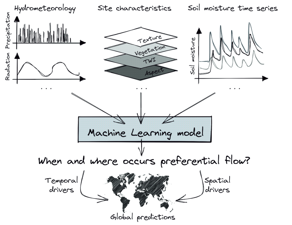
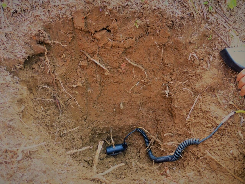
High-frequency multi-depth soil moisture observation for detecting preferential flow
Read the summary
Preferential flow (PF) is a subsurface bypass flow that rapidly transports water, impacting aquifer recharge, soil health, and contaminant spreads. However, there is currently no effective way to predict its occurrence and magnitude. This project addresses the fundamental question of where and when PF occurs by leveraging high-frequency and multi-depth soil moisture data from monitoring networks, that have become increasingly available globally in recent years. (c) Illustration: Matthitas Sprenger
USGS Powell Center project, PI: Dr. Matthias Sprenger, Dr. Pamela Sullivan, Dr. John Nimmo, Dr. Tianfan Xu
Forest Flows: Understanding how water flows through the land and plants in forests
Read the summary
(Under construction)
PI: Dr. Dean Meason
Catchment Hydrology
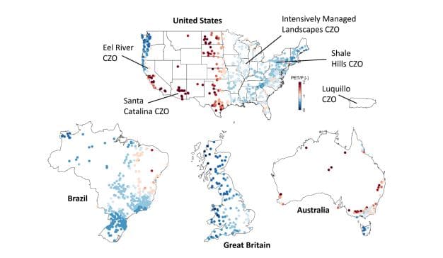
A framework to predict hydrologic processes at continental scales
Read the summary
Our team suggests hydrologic signatures, metrics representing watershed dynamics, as a new approach to estimating dominant processes. Using large-sample streamflow datasets (CAMELS) from the U.S., U.K., Brazil, and Australia, we investigate the links between hydrologic signatures and watershed processes.
PI: Dr. H. McMillan, Funded by NSF
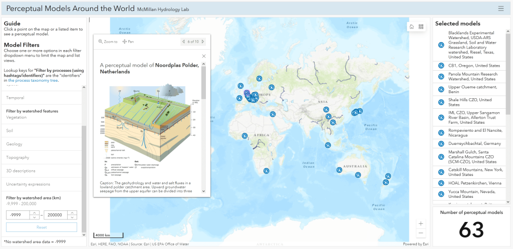
How do hydrologists perceive watersheds? A survey on perceptual models
Read the summary
Our team is investigating on how hydrologists perceive watershed systems by analyzing their conceptual illustrations in literature. Such illustrations are called ‘perceptual models,’ and are often used as blueprints of computational models. We explore the best guidelines to create perceptual models for the better knowledge sharing in hydrology.
PI: Dr. H. McMillan
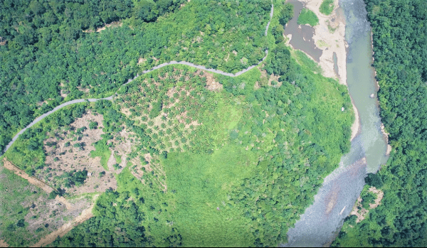
Rainfall infiltration reaches the groundwater table despite thick clay layers in humid tropical forests in Sumatra, Indonesia
Read the summary
Our team has conducted research on rainfall-runoff processes in humid tropics. Despite the presence of thick clayey soil layers, typically known for being impermeable, our team has found that groundwater tables respond quickly with large magnitudes in Indonesia, even in hillslopes with such soil characteristics. Through fieldwork and modeling, we have identified soil aggregation as the possible mechanism that allows for large infiltration flux in the soil layer.
These findings shed light on the behavior of rainfall infiltration in humid tropical forests, where previous studies were lacking. They will serve as a useful foundation for modeling hydrological processes in this area.
PI: Dr. T. Sayama, Funded by Kaken
US & California
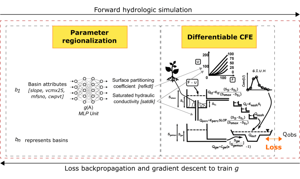
On numerical methods and differentiable modeling for soil process representations in the NextGen Framework in arid regions
Read the summary
We hypothesize soil physical processes in the arid regions are not adequately represented within Nextgen streamflow prediction models. To accurately model soil processes, we developed an Ordinary Differential Equation (ODE) representation of soil fluxes within the Conceptual Functional Equivalent Framework (CFE) model. We compared it to the existing framework using observed streamflow from 498 CAMELS basins. Furthermore, we applied physics-based machine learning (differential programming) approaches for CFE and the Layered Green & Ampt with Redistribution (LGAR) model to determine model parameters. The project was done at the CUAHSI NWC Summer Institute 2023.
PI: Dr. Jonathan Frame; Teams: Soelem Aafnan Bhuiyan; Tadd Bindas, Jeremy Rapp
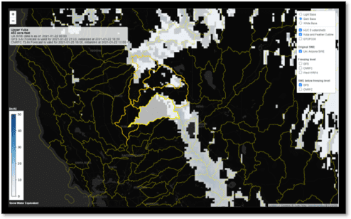
Snowmelt processes in the National Water Model during extreme Atmospheric River events
Read the summary
National Water Model (NWM) is a hydrologic model that simulates the streamflow over the entire continental United States. The project aims to assess and improve the prediction of rapid snowmelt caused by Rain-on-Snow events in the Sierra Nevada and Cascade Mountains by NWM.
I worked on reviewing the literature, compiling hydro-climatic data, and analyzing the soil moisture data. Moreover, I created a real-time webmap to visualize the rain-on-snow risks to inform decision-makers.
Advisor: Dr. H. McMillan, Dr. Ming Pan, Dr. Ty Brandt, Dr. Edwin Sumargo, Dr. Forest Cannon at CW3E at Scripps Institute of Oceanography, Funded by NOAA
Missing the main load? Quantifying marine debris loadings from storm drain and river margin sources in the San Diego River
Read the summary
Debris from rivers is a major contaminant in the San Diego coastal areas. We conduct field and lab works to model the “trash-balance” model in the San Diego River watershed – to quantify and identify the sources and the destinations of debris. I supervised three undergraduate students and led fieldwork in the project.
PI: Dr. H. McMillan, Dr. Trent Biggs, Funded by NOAA
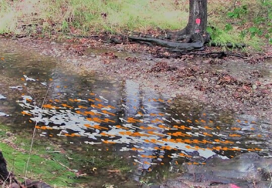
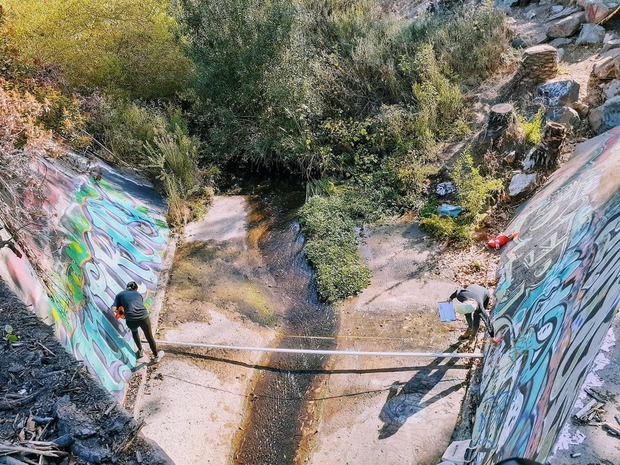
Canyon flow analysis with particle velocity imagery (PIV) technique in San Diego
Read the summary
Traditional measurements of river flow rates require contact with the flow. With the PIV (particle image velocimetry) technique, we can obtain the river surface’s 2-D velocity field without entering the river. PIV cross-correlates the particle in sequential images of the flowing river surface. Our group aims to assess the effectiveness and uncertainties of the PIV technique in small rivers (the river width around less than 10 meters).
I supervised two undergraduate students in setting up field sites, implementing the fieldwork, and analyzing the data with PIV.
PI: Dr. H.McMillan